Oregon’s largest wildfire burning in Wallowa County
Published 4:00 pm Tuesday, September 6, 2022
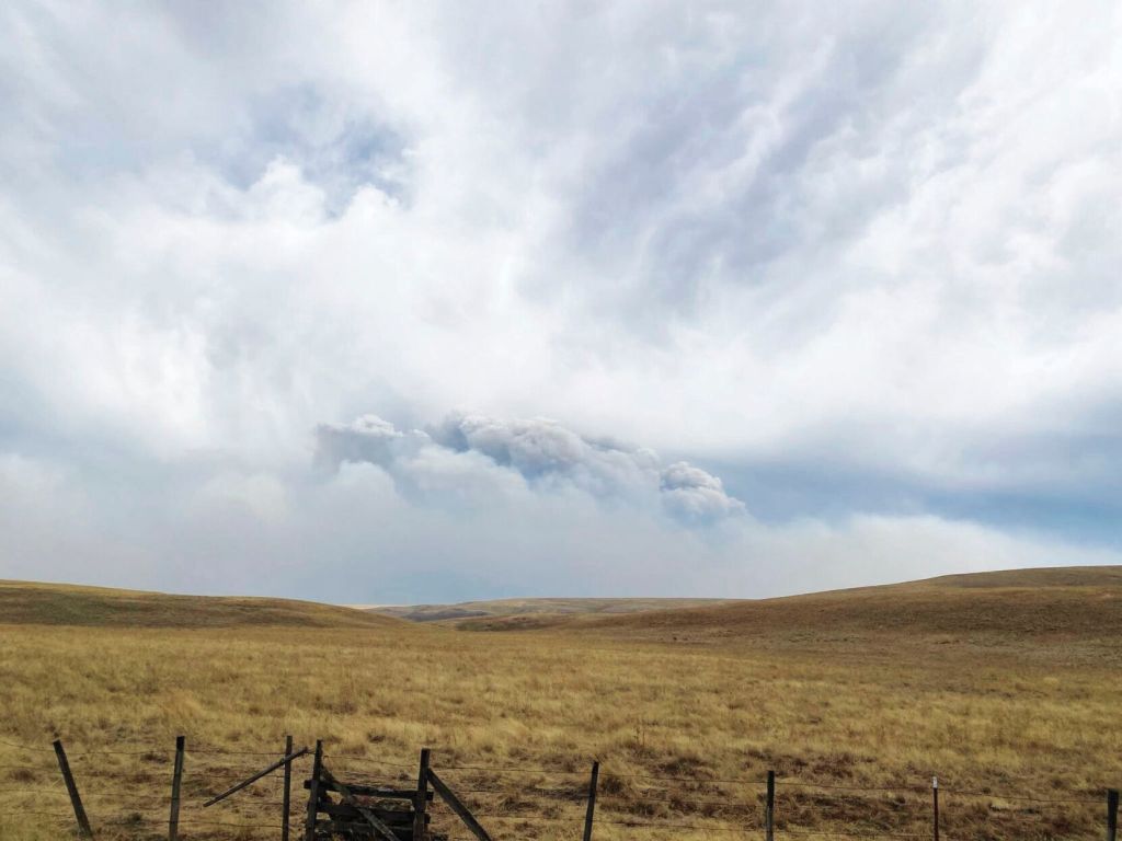
- Smoke expands Saturday, Sept. 3, 2022, from the Nebo fire in the Eagle Cap Wilderness in Northeastern Oregon.
Additional resources continued to arrive to help battle the both the Double Creek and Eagle Cap Wilderness fires in Wallowa County.
Trending
The Double Creek Fire is the largest wildfire burning in Oregon.
The fire has now burned 53,539 acres, according to the Sept. 5 update, up from the more than 37,800 acres reported on Sept. 4. The blaze is still 0% contained, and there are more than 580 personnel assigned to fight the fire.
Oregon Gov. Kate Brown invoked the Emergency Conflagration Act on Sept. 3 in response to the Double Creek Fire.
Trending
Strong winds, hot temperatures and humidity that dipped into single digits in places Sept. 3 also enabled two lightning-caused fires in the Eagle Cap Wilderness to grow substantially.
According to a press release from the Type 1 overhead team that’s managing the Double Creek and the wilderness fires, task forces from the State Fire Marshal’s office initiated structure protection on the Double Creek Fire, cleared brush and increased defensible space around homes along the Freezeout and Imnaha roads.
Firefighters secured a private inholding (Section 36) along Grizzly Ridge between Buck Point and Pumpkin Creek. Dozers cleared vegetation along the power line in the Imnaha River corridor. All the known hunting parties were safely evacuated from the area.
According to a release from the governor’s office, the declaration allows the Office of the State Fire Marshal to take unified command immediately. Wallowa County Sheriff Joel Fish has issued Level 3, Level 2 and Level 1 evacuation orders for homes near the fire.
Firefighters on Sept. 5 were scouting for additional options on the northern and southern portions of the fire. Crews will mop up and patrol around structures along Freezeout Road and north along the Upper Imnaha Road. Firing operations will continue along the Upper Imnaha Road to secure the fire backing down drainages to the east. State Fire Marshal task forces will continue to assist with structure protection along the Imnaha Road and ensuring the protection of life and property in the community of Imnaha.
Brown’s declaration cleared the way for the State Fire Marshal to mobilize firefighters and equipment to assist local resources battling the fire and further support a coordinated response.
Local mutual aid and federal resources are on scene working to slow the fire’s progress. An OSFM Incident Management Team assumed unified command Sept. 3 with federal partners. OSFM will bring in four additional task forces through the Oregon Fire Mutual Aid System from Lane, Clatsop, Washington and Yamhill counties to assist in the response.
The Double Creek Fire is a “full suppression” blaze, which means officials are trying to douse it as soon as possible.
The Wallowa County Sheriff’s Office on Sept. 4 modified the evacuation levels for the Double Creek Fire. A Level 3 “Go Now” is in effect for the town of Imnaha and south to Freezeout Road. The Upper Imnaha Road, Hat Point Road and Wallowa Mountain Loop Road (Forest Service Road 39) are closed. A Level 2 “Get Set” is in effect for the area from the town of Imnaha north to Fence Creek, including the lands east toward Lightning Creek. A Level 1 “Be Ready” is in effect from Freezeout south to the Pallette Ranch and
Imnaha River Woods.
The two fires in the wilderness, by contrast, are “managed” fires. That means officials are using a variety of tactics, monitoring the fires in some areas but taking actions, such as having helicopters drop water and dispatching firefighters on the ground, to try to limit the fires’ spread in certain directions.
Both wilderness fires — Sturgill, estimated at almost 14,300 acres on Sept. 6, and Nebo, estimated at 7,800 acres — have surpassed the 2019 Granite Gulch Fire as the biggest in the Eagle Cap Wilderness since the Wallowa-Whitman National Forest instituted a policy allowing lightning fires to burn naturally.
The Granite Gulch Fire burned about 5,500 acres in August and September 2019.
The Eagle Cap, at 365,000 acres, is the biggest federal wilderness in Oregon.
Besides the Sturgill and Nebo fires, there are two other fires, also sparked by lightning Aug. 22 or 23, in the wilderness. The Goat Mountain Fire 1 is not active, according to fire managers. The Goat Mountain 2 Fire is about 150 acres.
Sturgill fire
A group of firefighters is prepared to protect buildings on private parcels at Red’s Horse Ranch and the Minam River Lodge, both west of the Minam River. However, the fire remains east of the Minam River.
Nebo fire
On Sept. 3, the blaze crossed Big Sheep Creek and crested Wing Ridge to the north. The fire also burned outside the wilderness toward Forest Road 39. Firefighters that afternoon evacuated the Lick Creek Campground.
The following areas are closed to the public:
• Use of Forest Service Road 3900100 from the 39 Road junction to Tenderfoot Trailhead.
• Use of Forest Road 3925015 from junction of Forest Service Road 3925 to Lick Creek Trailhead.
• Use of Forest Road 3900200 from the 39 road junction to Forest Service Road 3925015 road .
• Use of Tenderfoot Trail (1819) from the Tenderfoot trailhead to the 1828 and 1812 trail junctions.
• Use of Lick Creek Trail (1809) from the Lick Creek Trailhead to the junction of the South Fork Imnaha Trail (1816).
Double Creek fireOn Sept. 3 the fire spread north along Grizzly Ridge and east toward the Snake River.
To the south, the fire moved down the Granny Creek drainage toward the Freezeout Road. Firefighters are working to protect private property along the Imnaha River corridor, but they had to take refuge several times on Sept. 3 due to intense and erratic fire behavior, according to fire managers.
Firefighters evacuated several groups of hunters in the area.
Although lighter winds are forecast on Sept. 4, fire officials expect the blaze to continue to spread on the east and west sides of Grizzly Ridge, and also grow to the north.
Flames also are likely to continue moving downslope toward the Imnaha River along Schleur, Adams, College, Double and Blackmore creeks. Firefighters on Sept. 4 worked with task forces from the Oregon Office of the State Fire Marshal to protect property and infrastructure along the Upper Imnaha Road.
SmokeSmoke is expected to settle in the lower elevations and drainages in the early morning hours. Current air quality information for the local area is available on the PurpleAir website.
EvacuationsThere are evacuations in place for the Double Creek Fire. Hat Point and Freezeout Roads are under a Level 3 “Go Now” evacuation. The Hat Point Road is closed due to the fire activity. Imnaha River Road, from Rippleton Creek to the Imnaha Grange is under a Level 2 “Get Set” evacuation. Imnaha River Road, from the town of Imnaha to Rippleton Creek and from the Imnaha Grange to the Pallette Ranch including Imnaha River Woods is under a Level 1 “Be Ready” evacuation. There are currently no evacuations for the Eagle Cap Wilderness Fires.
Crockets Knob fire
The other major blaze in the region is Crockets Knob, on the Malheur National Forest about 19 miles north of Prairie City. The fire, started by lightning on Aug. 22, has burned 4,280 acres and is 15% contained.
Marketplace


-
eEdition

-

-
