Phone failure: Mapping apps lead motorists into potentially dangerous situations
Published 7:00 am Thursday, December 14, 2023
- Ash
BAKER CITY — Smartphones can tap the world’s accumulated knowledge, but in one significant way they can be utterly ignorant about winter travel in Northeast Oregon.
Drivers who heed their phone’s misguided advice to take a particular road might at best be saddled with a hefty towing bill and a slog through snow.
At worst they might put their lives in peril.
Hundreds of miles of roads in the region, including many paved routes that are popular during balmier seasons, are not maintained during winter and are impassable, at least as through routes, for several months.
Yet some phone-based navigation apps will suggest those roads — in some cases even touting them as the shortest way — and lure unwary drivers into dangerous situations.
Sheriff’s offices and search and rescue teams around the region respond most years to at least a few reports of people whose vehicle bogged down in snow on a road that isn’t plowed during winter.
The episodes continue even as agencies install warning signs, post notices on websites and otherwise encourage motorists to stay on roads that are regularly maintained.
On the evening of Monday, Dec. 11, the Grant County Sheriff’s Office handled two such cases.
Both were on a section of road that has figured in more than a dozen such episodes over the past couple decades.
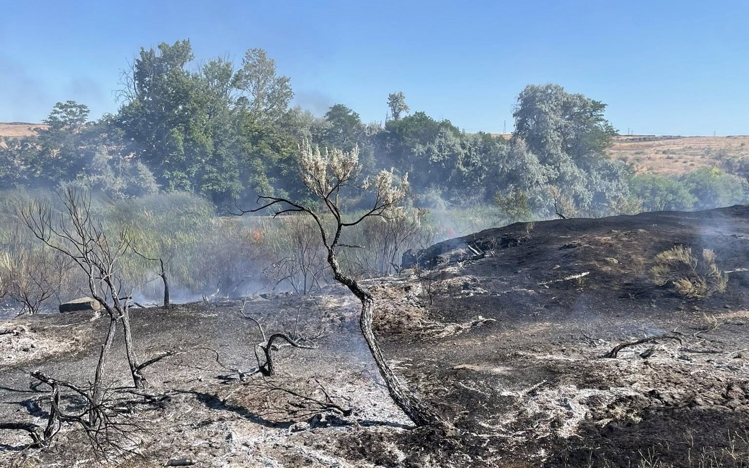
It’s the Elkhorn Drive Scenic Byway — Forest Road 73 in the Wallowa-Whitman National Forest west of Baker City.
During summer the two-lane paved highway is open over its entire 106-mile route. The byway passes Anthony Lakes, crosses Elkhorn Summit, at 7,392 feet the second-highest point on a paved road in Oregon, and connects to another byway, the Blue Mountain Scenic Byway, which leads to Ukiah.
But during winter, Road 73 is not maintained for 23 miles between Anthony Lakes Mountain Resort and Granite, in Grant County about 43 miles west of Baker City.
The Blue Mountain Scenic Byway, Forest Road 52, is not maintained, either.
Both drivers who got stuck in snow along Road 73 on the night of Dec. 11 relied on the Apple Maps app, which directed them to the byway as an alternate to Interstate 84, which was closed due to weather, Grant County Sheriff Todd McKinley said.
The detour looks simple enough on a map, to be sure — indeed, the byway is something of a direct route northwest to Highway 395 and thence to Pendleton and the freeway.
But in reality both byways traverse elevations well above 5,000 feet where several feet of snow accumulates most winters. Parts of both byways are more than a dozen miles from the nearest home.
One of the motorists stranded is from Florida, traveling alone and moving to a military base near Seattle, and the other, who had one passenger, is from Texas, relocating to Seattle for work, McKinley said.
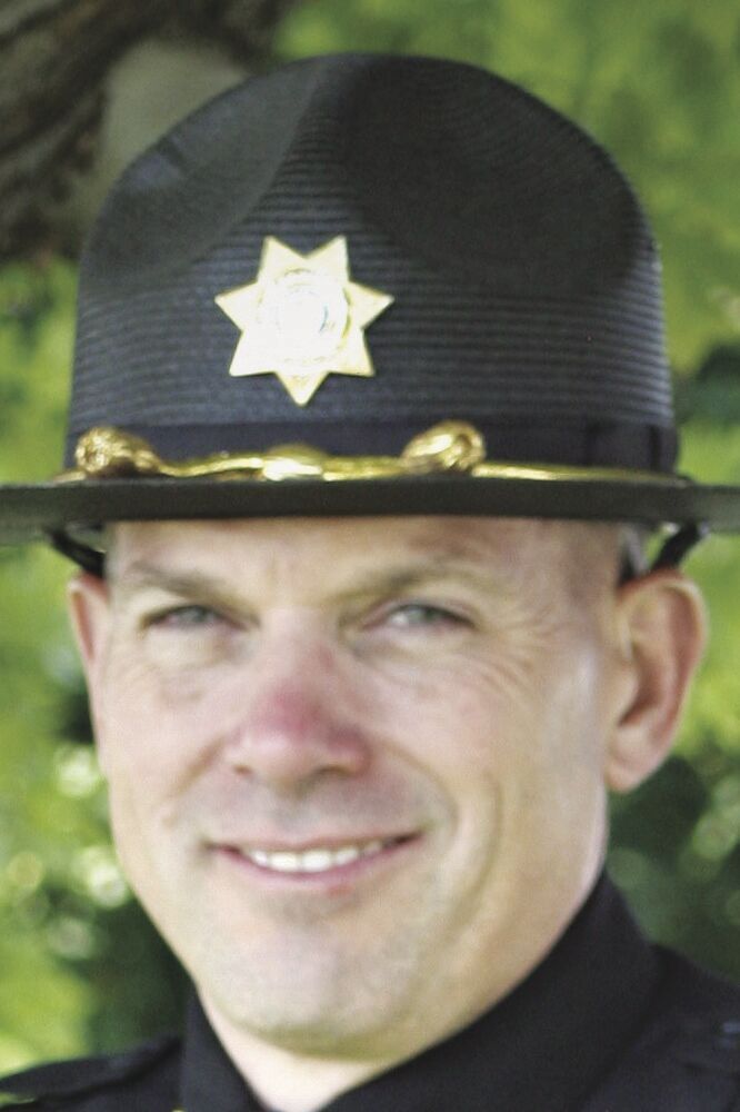
Both were stuck in snow on Road 73 north of Granite. They were trying to detour around the I-84 closure — a common reason for travelers, including commercial truck drivers, to seek alternate routes and to blithely trust their phone, said Travis Ash, Baker County sheriff.
The two stuck near Granite both sent 911 text messages that the Grant County Emergency Communication Center received — their iPhones have the capability of using satellites even when, as is the case in that area and in much of the remote parts of our region, there is no cell service, McKinley said.
“These roads appear as suggestions as routes on Apple Maps, and to the unsuspecting traveler, can lead to a long night, or worse,” McKinley said. “Please, when traveling, stay to well-defined roads, and do not venture onto the byways as it could lead to potentially fatal results.”
Fortunately, nothing dire happened Dec. 11, as McKinley extricated the vehicles and led the travelers to John Day.
McKinley said he always asks drivers, after he has rescued them, why they continued to drive even in deepening snow, and in some cases after having passed a warning sign.
He said the Florida man who got stuck on Road 73 was about 4 miles north of Granite when his two-wheel drive car finally got stuck, just before a steep section of road that climbs to Crane Flats.
McKinley said the man told him he was looking for a place to turn around.
“He was pushing snow,” McKinley said.
The Texas couple got stuck about 1 mile north of Granite.
McKinley said one of the pair sent 65 text messages to the emergency dispatch center.
“They were scared to death,” he said.
Problem areas
The travelers from Florida and Texas were hardly the first to get into trouble on Road 73 between Granite and Anthony Lakes.
There have been numerous similar mishaps both on that road and on the Blue Mountain byway, between Ukiah and the North Fork John Day River, over the past 20 years.
Drivers have been stuck both during winter and in spring, when melting snow makes the byways passable for many miles but lingering drifts continue to block the routes at higher elevations.
Almost exactly three years earlier, on Dec. 7, 2020, a San Diego couple, Sam Belknap and Shanda McDonald, got stuck in deep snow on Road 73 about 6 miles southwest of Anthony Lakes Mountain Resort.
Although there is no cell service in that area, the stranded motorists had a portable GPS unit equipped with a satellite connection that allowed them to send an emergency text.
Volunteers from the Baker County Sheriff’s Office’s Search and Rescue team, traveling in side-by-side ATVs equipped with tracks rather than tires, rescued the couple, who were unhurt.
In addition to Roads 73 and 52, McKinley said Grant County officials occasionally rescue people mired in snow along County and Forest Road 18. The route, which is not maintained during winter, connects Highway 26 near Prairie City to Long Creek, along Highway 395 north of Mount Vernon.
Although the county installed signs on the road, drivers sometimes fail to see, or ignore, the signs, relying instead on their phones, McKinley said.
“It’s a lack of common sense, it really is,” he said. “People get committed, they don’t want to go back. People trust that app beyond what they’re looking at or the actual conditions.”
Recently a commercial truck driver’s company dispatch center directed her onto Road 18, where she got stuck, McKinley said.
In Union County, rescuers have been called multiple times to Forest Road 51, a paved road that follows the upper Grande Ronde River beyond Starkey to its intersection with Road 52, the Blue Mountain Scenic Byway.
Nick Vora, Union County’s emergency manager and search and rescue coordinator, recalls an incident several years ago when a commercial truck driver traveling from Portland to Boise followed directions on his GPS unit to Road 51, where he got stuck in snow.
The driver ended up walking more than 10 miles in cowboy boots and jeans.
Although the driver wasn’t hurt, Vora said the episode “could have had a very different outcome if the weather had been different.”
Signs and barricades
Forest Road 39, also known as the Wallowa Mountain Loop Road, connects Highway 86 east of Halfway, in Baker County, to the Imnaha Highway east of Joseph in Wallowa County.
Like the Elkhorn Drive and Blue Mountain byways, it’s a two-lane paved road that is a popular drive during summer but is not maintained in the winter.
During the winter of 2020-21, after search and rescue crews had to help several drivers who got stuck in snow on the road, the Wallowa-Whitman National Forest installed barricades near the road’s junction with Highway 86 to warn drivers not only that the road is not maintained for wheeled vehicles, but that it is also a groomed snowmobile route. Under Oregon law, it’s illegal to drive a wheeled vehicle on a groomed snowmobile route during the snowmobiling season.
Ash, the Baker County sheriff who has rescued several stranded drivers on Road 39, said more obvious signs that the Forest Service installed at the intersection with Highway 86 about two years ago have proved effective.
Ash said he hasn’t received a single report of a driver stuck in snow on the road since then.
As is the case on Road 39, signs are posted along several other roadways to warn drivers that the route isn’t maintained for winter travel.
Dan Story, the road manager for the Whitman Ranger District on the Wallowa-Whitman, said he has installed prominent warning signs on Road 39 as well as Road 73 near Granite and near the Anthony Lakes Ski Area. Those signs state, among other things: “groomed snowmobile route no wheeled vehicles beyond this point,” “road closed,” “road closed for winter.”
Story said he believes the combination of more frequent freeway closures compared with past decades, and the prevalence of mapping aps and other navigation devices, constitutes a “perfect storm” that has contributed to the number of stranded motorists the past several years.
Vora credited the U.S. Forest Service with responding quickly after a rash of cases when drivers, following GPS directions, ventured onto a road that branches off the Mount Emily summit road, Forest Road 31 north of Interstate 84 near Meacham.
Although digital maps show a road leading to Five Points Creek and eventually to Fox Hill Road near La Grande, that road “no longer exists,” Vora said.
Several drivers got stuck or severely damaged their vehicles trying to make that nonexistent detour, he said.
Vora recalls in particular one vehicle that stalled when trying to cross ice-choked Five Points Creek. Water was up to the vehicle’s windows when rescuers arrived, he said.
Vora said that within a day of his making the request to the Forest Service, the agency had installed signs stating that the road is closed.
“The Forest Service has been an incredible partner,” he said.
There haven’t been any problems on that closed road since the Forest Service put up the signs, Vora said.
Ash said the Baker County Sheriff’s Office takes several steps when Interstate 84 closes to reduce the chances of drivers, and in particular commercial trucks, venturing onto unsuitable detours.
(Which, he said, is most of them — Ash recommends travelers stranded by a freeway closure to wait until the thoroughfare reopens.)
One that has proved effective is setting up a large portable readerboard along the Anthony Lakes Highway, before the road starts its twisting climb to the ski area, to warn drivers that the road is not a through route or alternate to the freeway.
The Powder River Rural Fire Protection District has a similar readerboard at its Mosquito Flats fire station near the intersection of Highway 7 and the Sumpter-Granite Highway.
Warning signs aren’t the only potential option to discourage drivers from making bad decisions.
McKinley said a locked gate blocks motorists from driving on the Blue Mountain Scenic Byway a few miles south of Ukiah.
Expensive for rescuers
Morrow County Sheriff John Bowles said his department averages about 25 to 30 “snow rescues” each year, most of those in higher elevations of the Blue Mountains in the southern part of the county.
“And unfortunately over the years, there have been a few deaths,” Bowles said.
Although local residents who are familiar with roads and winter conditions sometimes get stuck in snow by exceeding their vehicles’ capability, Bowles estimated that about half of the rescues in his county are similar to the ones that happened Dec. 11 in Grant County.
“I would say that probably at least half of them are from just following the GPS and just continuing,” he said. “We’ve even had semi-trucks go up there and get stuck.”
Besides putting travelers in danger, the episodes can be expensive for the sheriff’s office, Bowles said.
“So anytime we have a snow rescue it takes a half a dozen of my staff,” he said. “Most of the times they’re on overtime at that time, and many times it’s myself or my undersheriff involved as well. And we’re up there for many hours. Trying to get these people out safely.”
‘Smarter’ GPS and mapping apps
Vora said one of the most helpful changes, made a couple years ago, was the Oregon Department of Transportation, which operates the tripcheck.com highway condition website, allowing county and Forest Service officials to add secondary roads to maps on the website, along with notes designating those routes as being closed during the winter.
Tripcheck.com now shows many such routes, including the Elkhorn Drive and Blue Mountain byways, the Wallowa Mountain Loop Road, Road 51 along the upper Grande Ronde, and Morgan Lake, Fox Hill and Robbs Hill roads, all near La Grande.
Baker and Grant county officials also have used the feature on tripcheck.com to show roads that aren’t maintained during winter and are not viable detours during freeway closures.
Story, the Forest Service road manager, said he believes the tripcheck.com option is a valuable tool for local officials.
Although not all travelers, particularly those from outside Oregon, are familiar with tripcheck.com, Vora said some mapping apps, which try to provide users with updated travel conditions, gather details from tripcheck.com. That means the apps that many travelers use could potentially dissuade, rather than entice, motorists from trying local routes that aren’t passable.
Snowmobile routes
Drivers occasionally mistakenly believe that a road groomed for snowmobiles has actually been plowed and is open to wheeled vehicles.
A groomer, like a snowplow, creates a snow berm on both sides of the road.
And after an extended dry spell, the passage of snowmobiles can pack the snow so firmly that even wheeled vehicles won’t sink in — until, as McKinley points out, the temperature warms and the snow softens.
Such an incident happened in February 2015, and two people sustained minor frostbite and hypothermia during the ordeal.
McKinley, then the Grant County undersheriff, rescued the two women on Road 52 about 17 miles northwest of Granite.
The husband of one of the women had walked the 17 miles to Granite to call for help. When rescuers didn’t show up after a day or so, the two women also started walking toward Granite, making a couple miles, despite one of them wearing open-toed shoes, before McKinley arrived.
Being prepared
Although sheriffs urge travelers to use common sense rather than relying on potentially flawed phone apps, they also recommend that all drivers stock their vehicles with emergency supplies during winter.
Even when you’re traveling on a well-maintained route, such as Interstate 84, blizzards or crashes can close the road for hours, potentially leaving drivers stranded.
Bowles suggests drivers pack “blankets, water, clothes, snacks, that type of thing. And just be prepared.”
“It’s a lack of common sense, it really is. People get committed, they don’t want to go back. People trust that app beyond what they’re looking at or the actual conditions.”
— Grant County Sheriff Todd McKinley