‘I want people to have the time to get out’
Published 5:00 am Tuesday, August 13, 2024
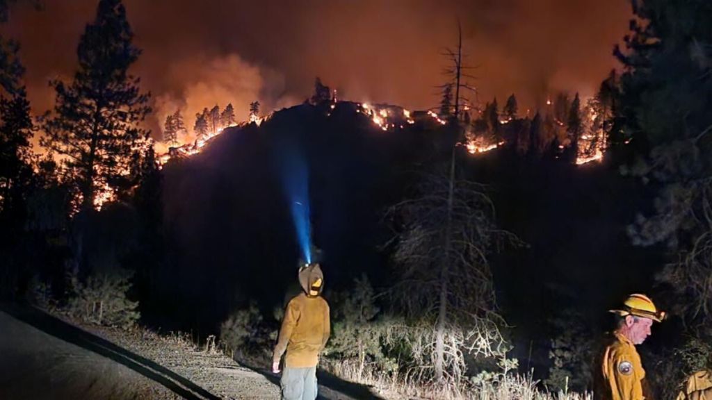
- The Town Gulch Fire made a massive run on Aug. 6, 2024, spreading east to the West Wall above Pine Valley.
BAKER CITY — Baker County Sheriff Travis Ash considers several factors when setting evacuation levels during a wildfire but his guiding principle is a single, simple matter.
Trending
Time.
“I want people to have time to get out,” Ash said.
Because the matter of a few minutes potentially can save lives, Ash said when he designates evacuation levels initially, when a fire is growing, he is “aggressive.”
Trending
He bases his decisions on the weather and terrain, conversations with firefighters, the proximity of homes and the road access. An area with a a single road for access, for instance, is more likely to warrant a higher evacuation level because congestion could mean residents need more time to leave, he said.
Ash said he would rather be overly cautious, in setting evacuation levels, than to underestimate a fire and leave residents without sufficient warning of the potential danger as the flames advance.
The unprecedented rash of wildfires in Northeastern Oregon this summer illustrates the risk.
The Durkee Fire, for instance, which a lightning bolt started July 17 in Baker County, raced 18 miles in one day, Ash said, propelled by gusty winds and fed by grass and brush turned to tinder during the most severe heat wave in the county’s history.
“I don’t want anybody to be surprised,” Ash said.
In Oregon, each of the 36 county sheriffs is responsible for issuing evacuation notices.
Tribal police departments determine levels on American Indian reservations.
Oregon uses a three-level evacuation system.
Level 3 is the most serious, deemed the “go now” level. It’s for areas where a fire poses an immediate threat to people and structures.
Although sheriffs can issue Level 3 notices, Ash said they can’t mandate that people leave their homes.
Level 2 is the intermediate level, meaning residents should be prepared to leave at a moment’s notice.
Level 1 is the “be ready” designation, meaning residents should pack important papers and other valuable items and continue to monitor the situation in case a Level 2 or 3 notice is warranted.
Ash, who started his law enforcement career in 1998 with the Prineville Police Department, joined the Baker County Sheriff’s Office in 2005 and has been sheriff since 2015, said the 2024 fire season has been historic.
“We haven’t had a fire season like this,” he said on Aug. 9.
Ash on that day was continuing to monitor the Town Gulch Fire, a lightning-sparked blaze that has burned 18,500 acres in eastern Baker County.
Firefighters had substantial progress on the fire, but Level 1, 2 and 3 notices remained in effect.
Ash said the Town Gulch Fire epitomized the “very chaotic” situation that can prevail when a wildfire is burning out of control.
On Aug. 6, a combination of wind, heat and low humidity contributed to the fire growing by more than tenfold.
Ash said he was stationed along the Eagle Creek Road north of Richland, where the fire had started. Parts of the area were already under a Level 3 notice.
Ash said he was monitoring radio traffic from aircraft dropping retardant and water on the fire. When he heard that pilots were predicting the fire would reach a main Forest Service road in about 20 minutes, and the top of the West Wall, the heavily timbered ridge on the west side of Pine Valley near Halfway, within an hour, Ash said he immediately expanded the Level 3 zone and converted some Level 1 areas to Level 3.
He said while a quick look at a map showed how fast the fire was moving, based on the pilots’ predictions, his local knowledge of the geography and terrain also was helpful.
He is a 1993 graduate of Pine Eagle High School in Halfway, and he grew up in the area.
During the Durkee Fire, Ash said he relied on information from fire bosses as well as local residents, including ranchers Levi Bunch and Bert Siddoway, whose familiarity with the topography gave him a better sense of where the fire was likely to spread.
“Local knowledge always helps,” Ash said.
Jason Yencopal, the county’s emergency management director, creates maps showing evacuation levels — red for Level 3, yellow for Level 2 and green for Level 1.
Ash said it’s important to base evacuation levels on boundaries that residents can quickly understand, such as prominent roads.
He said although he will upgrade a warning to Level 3 as soon as a fire poses an immediate threat, he is more conservative in reducing warning levels.
He said he strives to avoid the “yo-yo” effect — jumping between levels multiple times for the same fire — because it can confuse residents.
Ash said he lowers evacuation levels only after confirming with fire bosses that a blaze no longer poses any significant threat to a particular area.


-
eEdition

-

-
